By Sidhi Jain
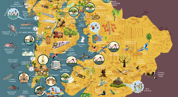
New Delhi, July 8: A unique Interactive Biodiversity Map presented by The Ministry of Mumbai’s Magic aims to inspire and educate the citizens of Mumbai about the city’s rich biodiversity. It was launched on Wednesday. Illustrated by well-known cartoonist, Rohan Chakravarty, a.k.a Green Humour, whose artworks are inspired by themes of wildlife conservation, the map highlights the biodiversity that thrives in Mumbai’s Metropolitan region.
The map is being launched with the objective to invigorate a sense of ownership amongst Mumbaikars to take responsibility towards protecting and fostering their city’s biodiversity.
First launched in 2020 as a static map, the new interactive map will document different species with clickable features that present details of the species, their habitats and their conservation status. The map covers the Mumbai Metropolitan Region and the water bodies of Thane Creek, Mahim Bay, Vasai Creek and the Arabian Sea. Highlighting 17 species of flora and 78 species of fauna, the map also emphasizes the interdependence of the Indigenous Communities — Adivasis and Kolis — on the local biodiversity for their livelihoods.
Mumba’s Ministry of Magic (MMM) is a platform to unite citizens and showcase their collective action, mobilizing them to draw the attention of the local government to prioritise protection of Mumbai’s biodiversity hotspots, green spaces and its inhabitants.
“Illustrations can make a lasting impression on one’s mind. Mumbai has always been portrayed as the city of glamour, speed, and everything urban. Yet, it remains green at the heart. This map is a true reflection of what this city represents, an island of diversity with a bucket full of dreams and a treasure trove of natural wonders,” says Rajesh Sanap, researcher and wildlife photographer.
Developed as an engaging and interactive digital experience, the Biodiversity Map will support the works of local citizens – local photographers and wildlife experts such as Rajesh Sanap, Kane Lew, Ashish Chalapuram, Pradip Patade and Vandan Jhaveri having contributed photographs and their expertise. The map will also be used as a tool to educate children at local schools, raising awareness of Mumbai’s precious ecosystems and encouraging citizens to reconnect with the ecosystems in the city.
“Making the map interactive increases the scope of this project by leaps and bounds because now we can reach a wide section of the young audience that uses the internet. This is a resource that is available at a click which is very difficult to obtain because if you had to look up the biodiversity of Mumbai — firstly, it is a very vast topic in itself and secondly, there is so much information dispersed far and wide on the internet that it would take time to collate all of that data,” Rohan Chakravarty, Cartoonist — Green Humour tells IANSlife.
Alongside information on the local flora and fauna the map will provide information on volunteering opportunities with local conservation organisations — enabling Mubaikers to use their skills to protect the unique local ecosystem.
“The biodiversity map of Mumbai has excited Mumbaikars across the spectrum. Students, parents, young professionals, conservation experts and even decision makers; it managed to unite and invoke pride in their city and its rich biodiversity. Our interactions with people and also the media interest proved that the creative aspect of this map has the potential to unite people. So as a natural next step, we now want to move people to action. The interactive version of the map that both deep dives into the city’s flora and fauna as well as showcases local organizations who have been working to conserve it is a step towards that,” Arpita Bhagat, MMM Campaign Lead says.
